Knowing Your Property 101
How much do you know about where you live? Many homeowners find out that there is a lot to learn about a home and property when you first buy or lease- In fact, it can be overwhelming! So when your Landscape Architect comes around wanting to see your survey and floorplan, you may think, “Oh no, not again,” or the even more common, “Where on earth did I put those?” While these documents look like they’re written in code, they provide an incredible amount of information that can be empowering once you know how to read them! So if you’d like, go on a quest for your property information, roll it out and follow along on this crash-course for property understanding that is, after all, your right as a homeowner.
Surveys, Measures & Assessor’s Maps
When it comes to informational property documents, there’s a lot out there. When we begin a landscape, we generally look for the following:
Surveys (documents that show measurements, created by licensed land surveyors)
Measures (documents that show measurements but are not created by licensed surveyors)
Assessor’s Maps or Parcel Maps (documents that show a site in relation to its surroundings, often available at county offices or online)
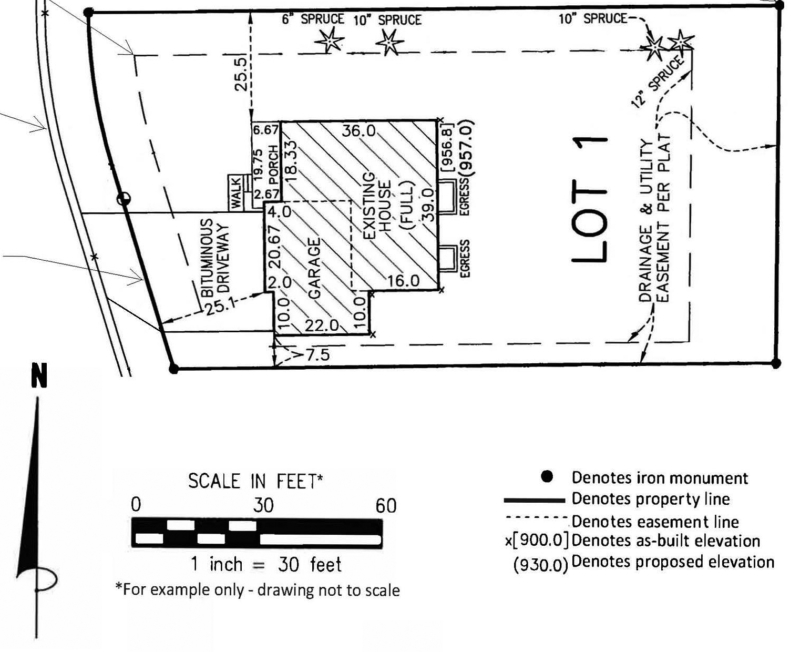
Shown above is a very basic example of a site measure. It shows simple (but valuable!) information, namely the location of the house on the lot and the overall shape of the property. Those finely dashed lines with the numbers attached indicate the distance of the house corners from the property lines. It also shows the length of the home’s walls, and the general location of several trees on the property, as well as an easement (which we’ll cover next.) Amazingly, this little document would give your Landscape Architects a lot to go off of! We could lay out an entire design just with this, but our profession requires us to go a bit deeper, particularly if we’ll be designing anything requiring a permit, and we almost always are.
Lines and Numbers
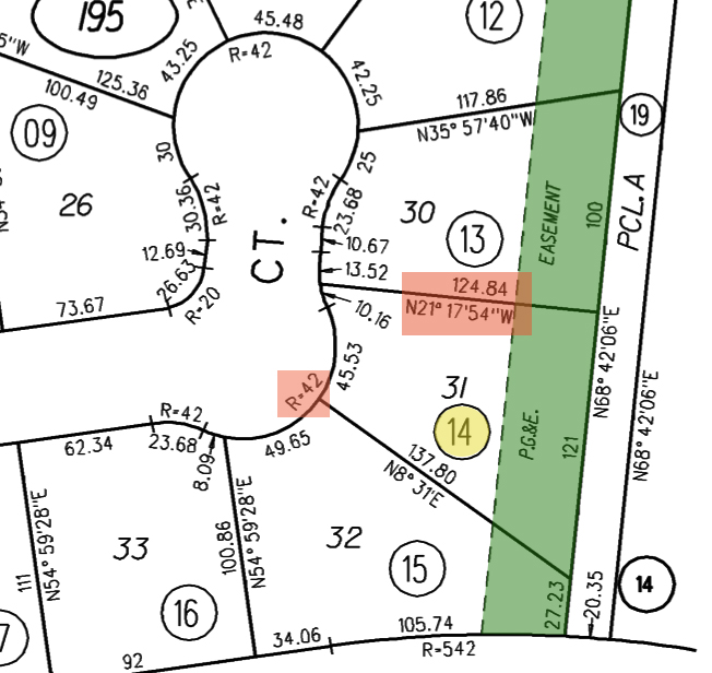
There’s a lot that goes on in these kinds of documents, so we’ve done a little highlighting to clarify on this Assessor’s Map of randomly selected properties in Walnut Creek. (Contra Costa County maps are available online- click here and just type in your address. Or, try searching for your county name.) Looking at the map above, first you may notice the numbers associated with each property – Number 14 highlighted in yellow. This is a parcel number, sometimes useful information later on. Second, you may notice the salmon-highlighted numbers at the property lines. As per tradition, the length of the property line appears on one side in feet (124.84 feet is the length here) and the bearing or compass direction of the boundary on the other side (N21° 17’54”W.) This will help your architect generate a highly accurate model of your site. Finally, you may notice the green-highlighted utility easement, and if this were your property, you might have some questions.
Set Your Mind at Ease(ment)
Alright, what is an easement doing on your property and what does it mean? It indicates that your property is located near land that has certain protections or needs surrounding it, and that these affect your property where the two intersect. Different kinds of easements exist – Scenic Easements, Utility Easements, and Access Easements are the most common, and all have their own rules. If you lived in parcel number 14 on the map above, with a utility easement, PG&E would reserve the right to enter that part of your property to do repairs (which might or might not restrict your ability to build there – you’d have to talk with the county for more details.) This is similar to a ROW (Right Of Way) easement, which implies that a public service, company or individual has the right to pass through part of your property on a regular basis (this is most common with roads or driveways.)
A Setback is similar to an easement and specifically controls proximity of buildings to property lines or to a riparian zone, kind of like a legal personal space bubble. Finally, a Building Envelope is a common sight on newly-zoned properties that have not yet had a structure built. This dictates where on the site you can build a house and how large the floorplan can be. Now that you know the facts, here’s the relief – Normally these kinds of rules are very reasonable, and it’s easy to create a beautiful home and landscape within them. And don’t be fooled by the name – a setback doesn’t have to set anyone back – It can be an excuse for a gorgeous path or planted area that could become the best part of your landscape. Once your Outdoor Living space is created, you’ll probably forget you ever had easements. (Hopefully you’ll also forget about that terrible pun, sorry!)
Coding and Zoning
If some of you are zoning out, bear with us. This next section about Zoning is our last for today! Zoning and Municipal Codes are the kind of thing many homeowners are unaware of, and in most cases that’s perfectly fine. Knowing where your property is on a Zoning map, and which Municipal Codes affect you, are usually not important unless it comes to a permit process. (It will also inform you whether or not you can have a horse on your land, but that may or may not be important to you.) The most frequent zoning restrictions we find tend to affect the heights of structures, but sometimes there are other laws written into a particular site. It’s always best to know all the details!
Finally, let’s touch quickly on HOA’s (Home-owner’s Organizations) and their CC&R’s (Covenants, Conditions & Restrictions.) Usually if you are part of an HOA, you know that these codes dictate certain things about your house, but they also can dictate certain things in your landscape. For example, Blackhawk HOA has specific requirements for styles of fences and mailbox pillars, among other aesthetic standards. It also prohibits the use of gravel as a mulch as an aesthetic and maintenance standard. Good to know!
So now you know what we’re up to when we say we are gathering data for your landscape! Sometimes this information is easily accessible, and sometimes we have to connect with surveyors and technicians to map terrain or details that haven’t been mapped before. In the end, we use all of this information (and so much more) to design your real-world landscape. We hope you’ve learned something today you didn’t know about your property!
Happy New Year everyone! Wow, it sure is great to be in 2021. We are excited to be taking new clients, so if your resolution this year is to take steps towards an Outdoor Living space that fits your lifestyle, let’s make it happen!

